
Mount Swansea West Ridge -Recreation Sites and Trails BC (one way distance)
Columbia Valley Greenways Trail Alliance
Invermere
-
6.23 km
Distance
-
751.63 mElevation Gain

-
977.58 mTrail Head Elevation

-
1729.21 mMaximum Elevation

-
839.77 mCumulative Elevation

-
3-5 hour(s)
Average Time
Click on an image to enlarge

Trail Description
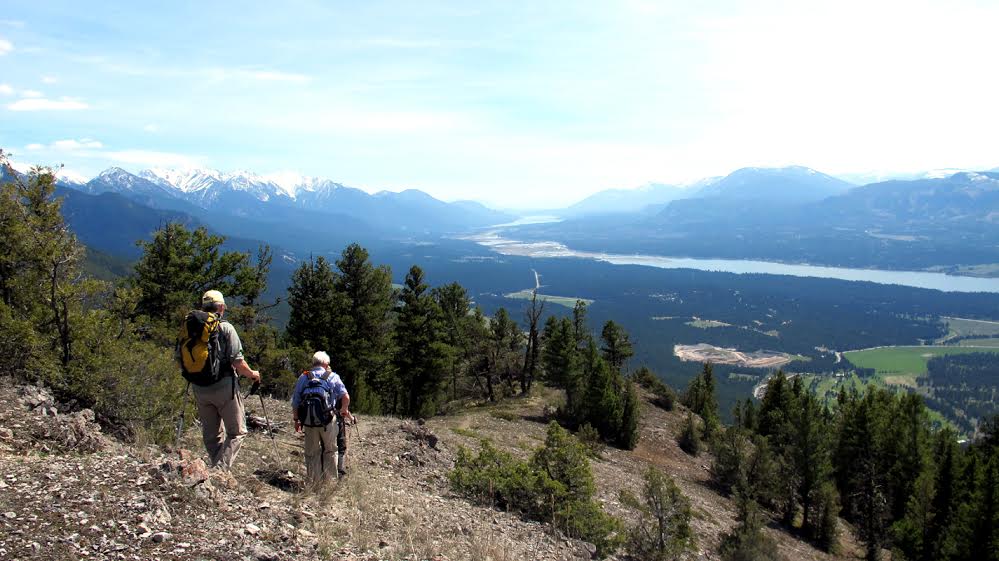
The Mount Swansea trail has a lot going for it; close to Invermere, good road access, good exercise (750 m elevation gain), and great views of the developed Columbia Valley to the west and the relatively undeveloped view to the east. The network of trails on Mt Swansea is shared between hikers and bikers. Some trails are single use while others are shared, so be mindful of the signs and use common courtesy when meeting the downhill mountain bikers. The trail that starts at the bottom parking lot travels 6.2 km along the west ridge. Choosing the left forks keeps you on the west ridge for the best views of the Invermere Valley (See Mount Swansea SE Ridge for alternate route). Alternatively, you can get to the ridge by driving to the top parking lot on a rough Forestry Service Road that switchbacks up the mountain. From the top parking lot, the peak is a 15 minute walk (100 m elevation gain/0.6 km). Once at the top enjoy the panoramic views and if you’re lucky you’ll see some hang-gliders taking off from the ramps on top. There is a picnic table and outhouse at the top.

Directions to Trail Head
From the traffic lights on Highway 93/95 at the Invermere junction, travel approximately 6 km south on Highway 93. Turn left on Windermere Loop Road. Continue on past the golf course for about 1 km. Turn right on Swansea Mountain Forest Service Road. Cross over Westroc Mine Road to a parking area on your left about 200 m up the road. Park in the bottom parking lot for the full hike or drive another 5 km up the Swansea Forest Service Road for a short 15 min hike to the top.

Detailed Map

Elevation Profile

Planned Mainenance and Trail Events
This trail is actively maintained by the Summit Trail Makers Society in partnership with Recreation Sites and Trails. Please report any maintenance issues directly to them - summittrailmakers@gmail.com

Trail Surface
variable outdoor terrain

Trail Season
Early Spring - Early Winter

Points of Interest

Uncommon Hazards
Watch for cyclists
Trail Features
Print Trail Information